Home > Ocean > Oceanography > Geography of the Sea
Geography of the Sea
In the brief history of ocean exploration some of the most fascinating discoveries about the geology of the sea floor have changed the way humans had viewed the sea for hundreds of years. No longer is the sea considered to be a bottomless, black abyss, the sea floor a vast expanse of cold, flat, lifeless watery desert. In the last 30 years, modern technologies have been used to map the topography of the sea floor, revealing a profile of the sea floor that is anything but flat and lifeless. The sea bed has been found to be riddled with massive geologic formations that mimic those we have on land, but on a much, much grander scale. Some of the most notable discoveries have been deep ocean canyons, which rival the Grand Canyon, seemingly endless underwater mountain chains that run thousands of miles; deep trenches, sea mounts, and coral reefs and atolls formed not by the geologic processes of earth, but by the diligence of tiny organisms over thousands of years.
How Scientists Map the Sea Floor
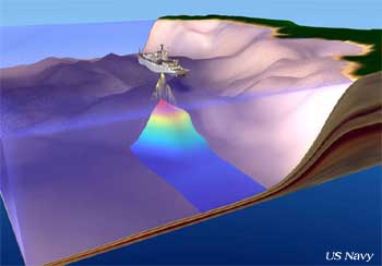
 The United States Navy is primarily responsible for gathering much of the data on the topography of the ocean bottom using sounding technology called an echo sounder. What an echo sounder does is send high frequency sound waves (that the human ear can't hear) through the water down to the ocean bottom. Sound waves will travel through water, even faster than they travel through the air, and bounce off solid objects, such as the ocean bottom. The echo sounder measures precisely how long it takes for the sound waves to be returned to the surface and determines the depth based on the rate of return. These soundings are plotted on a graph by a computer to make an "echo map" of the ocean bottom. The United States Navy is primarily responsible for gathering much of the data on the topography of the ocean bottom using sounding technology called an echo sounder. What an echo sounder does is send high frequency sound waves (that the human ear can't hear) through the water down to the ocean bottom. Sound waves will travel through water, even faster than they travel through the air, and bounce off solid objects, such as the ocean bottom. The echo sounder measures precisely how long it takes for the sound waves to be returned to the surface and determines the depth based on the rate of return. These soundings are plotted on a graph by a computer to make an "echo map" of the ocean bottom.
Abyssal Plain
Continental Shelves
Submarine Canyons
Coral Reefs
Sea Mounts
Mid-ocean Ridges
Volcanic Islands
Deep Ocean Trenches
|
|

